
Nechako Reservoir Paddle
Pandosy Bay from Eutsuk Lake - Day 11
I'd like to dedicate this trip to:
My dear wife. Missed my 32nd year wedding anniversary on June 2 (day 7 of the journey). Missed her very much.
My dear Aunt Nuala who passed away on May 27th, on the very first day of this journey where I lost touch with civilization. I did not find out about her passing until I got back in cell phone range on June 8th. It was with great sadness that I had to find out about this later, on the trip back home. She will be greatly missed. A bitter sweet ending to an extraordinary journey.
I would also like to give a special thanks to Theo and Katharina who went out of their way to help us on day 7 of our journey (i.e. getting around the Redfern Rapids). They own and operate the Tetatchuck Lodge near the Redfern Rapids. A beautiful, secluded resort that I would love to visit again some day.
Introduction
A journey of a thousand miles begins with a single step.
- Lao-tzu, The Way of Lao-tzu, Chinese philosopher (604 - 531 BC)
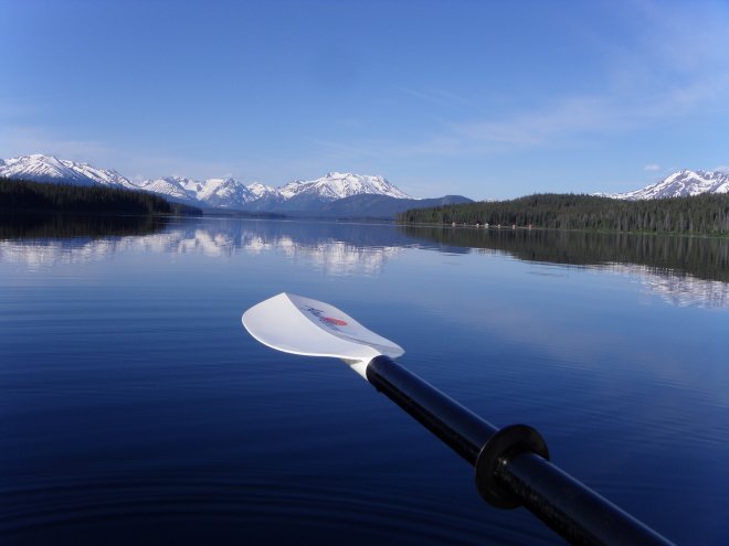
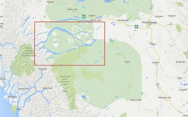
In my case this journey began with a single stroke of a kayak paddle for a total distance of three hundred twentyfive kilometres or just over two hundred miles on the Nechako Reservoir in the central northern region of British Columbia known as the Bulkley-Nechako region south of Burns Lake. This reservoir exists as a result of the Kenney Dam. This dam eventually connected a series of lakes and rivers to form the circle you see in the map below.
The idea of paddling this circuit came about as a result of an evening get together with my friends Maria and Arnie who are avid and very experienced outdoors people and paddlers. In fact this journey would have never happened for me without them. They had been thinking about this trip for a long time but needed at least one other paddler/boat to go with them. In retrospect, I can now see why.
For the most part Maria planned the meals for this trip estimated at about 14 days with 2 – 3 days of contingency. Since Maria and Arnie have done the Bowron Lakes about 10 times and many other significant paddling trips in Canada and other parts of the world, I figured it was best to let them arrange the main meals (dinners) for all three of us. These meals would turn out to be amazing considering the wilderness camping that had to be done after paddling each day.
I guess I should start off by saying that this was my first real, multi-day paddling trip. All of the paddling that I had done up until this point were, at best, one to two over night trips. So, needless to say, this was a trip beyond anything I could ever have imagined and I was a little apprehensive about doing something of this magnitude. But, in hindsight, it is clear to me that one must get out of their comfort zones in order to experience great things. Furthermore, the benefits gained from such experiences change you in ways you can't understand until they are experienced.
“The challenge of the unknown future is so much more exciting than the stories of the
accomplished past.”
- Simon Sinek
This journey started with a two day drive from Abbotsford, B.C. to our launch point at Little Andrews Bay on Ootsa Lake. Since my focus is on the actual paddling expedition, I won't get into any details on the two day journey to get up there other than to say that we camped at a beautiful forestry campsite, for the one night, called Cobb Lake just north of highway 16 (Yellowhead hwy) down a road called Finnmoore Rd. between Prince George and Vanderhoof. The trout were jumping like crazy in this lake and the campsites were very nice.
There are a few overview items I'd like to cover before I get into the main story itself. These things may seem somewhat trivial but I feel they are necessary to set the stage for a trip of this magnitude.
Overview
Forestry Services Offices
We decided to check in at both the Vanderhoof and Burns Lake Forestry Services offices. The check in was primarily for the purpose of providing them with details about ourselves and a trip plan. We were also interested in obtaining any information or any insights about what we might be up against. Both locations were more than happy to provide us with input and were very interested in what we were planning to do. The Vanderhoof officers did say that the Burns Lake office would have more details (i.e. the Burns Lake office was officially the correct catchment office for the Nechako Reservoir). But, nonetheless, both offices were very helpful.
However, it is worth noting that neither of the offices had much information or even accurate information about certain aspects of this circuit. For example, no one really knew what we would run into with the 5 km portage to get around the Redfern rapids. The search and rescue officer at the Burns Lake office gave us the impression that the trail was going to be good and that we would be able to use our wheels/carts to transport our boats through most of that trail.
As it turned out, this couldn't have been further from the truth. A major part of this trip would turn out to revolve around the difficulties we ran into to get around these rapids because of two things. First, the exact location of the trail and second, the condition of the trail. This will be explained later on days 7, 8, and 9. We originally estimated 1 day to get around the rapids. It turned out to be 3 days (i.e. the 3rd day being a day of rest to recover from exhaustion from the previous two days).
Anyway, I think it is suffice to say that the Nechako Reservoir paddling circuit is not well known or documented. In fact, at this time, we believe that our group may be the first to ever paddle the entire circuit. Neither the forestry services officers nor the two first nations men we came across at one of our camps have ever heard of anyone doing this loop in paddle boats.
Bear Awareness & Bear Caching For Food (A General Comment)
Obviously this pertains to any trip in the Canadian wilderness. This area (Nechako) is bear country or, more accurately, “their” country. We needed to be constantly aware of this fact and saw plenty evidence of bears in some of the locations we camped in. Therefore, it was imperative that we carry bear spray with us at all times and pay close attention to our use and storage of food and any other scented items.
The first order of business when stopping for the day to camp was to look around for bear scat, tracks, tree scratching etc. If there were significant signs we would probably have to move on to another spot. Luckily our landing points ended up not having too many signs (and sometimes no signs).
Regardless, in the evenings at our camps we needed to figure out where to cache our food. We had two containers that held our food. A large barrel with the bulk of our food and a smaller bear proof barrel. The large barrel was the main concern because it was not really bear proof. So we had to consider hanging it up in trees (generally). On a few occasions we had some really nice options. For example, at the Alcan Spillway recreational camp site, we had bear proof garbage containers that could hold all the food related containers. Since no one was around at the time, these containers were pretty much empty for our use only.
We also had to pay close attention to any food that dropped on the ground or on our clothes. If, for example, you were to drop/spill some food on your clothing you would need to cache that as well. The last thing you want to do is to go to sleep in your tent with food smells in it.
Essentially anything that is scented can put you at risk (e.g. medication (pills), toothpaste, perfume and/or deodorant, any food...).
This is just the reality of camping in bear country.
We only saw one bear the whole time we were out there. We saw a black bear from our boats out on the water looking at a clearing on a hill. Although there were bear signs in some of the places we camped we didn't see them and that's a good thing.
Truth be told, I'm more afraid of people than I am of bears!
Overall strategy
I've decided to break this journey up into three sections:
- Stage 1 - Little Andrews Bay to Jim Smith Point (generally eastbound and southbound)
- Stage 2 - Jim Smith Point to the Sand Cabin Bay (mostly westbound with the probability of very high winds against us)
- Stage 3 - Sand Cabin Bay back to Little Andrews Bay on Ootsa Lake (i.e. the home run)
From everything that we were told at both the Vanderhoof and Burns Lake forestry offices, we needed to be concerned about high winds and rough waters especially on the second and third sections (i.e. Jim Smith Point to the ranger station and Whitesail Lake). We were told that the lake named Whitesail was named that way because the waves from high winds look like white sails when things really pick up and they do most days.
The other issue with Whitesail Lake was that, when the water is rough, this can cause boaters some serious problems because of all the dead trees in the water along the shore. Boaters can get caught up in the trees and get smashed around by the wind and the waves. We also found out while we were actually on the lake itself that there are very few places to land a boat.
In fact it is also important to note that most of the water around this circuit exists because of the Kenney Dam. So much of the shorelines along these lakes have dead forests in the water and make it difficult to approach the shores. We also had to watch carefully, while paddling in these areas, to not to collide into dead heads just slightly under the water.
The decision was made that we would do the 325 km loop in a clockwise direction. So, from Little Andrews Bay, we would paddle east on Ootsa Lake, which is very large, down to Jim Smith Point. The main reason for this is that the prevailing winds are westerly. So on the biggest lake we would have the wind on our backs. This proved to be the right choice.
After the first day of paddling which started just before 8 am, we decided to start much earlier in the morning because the lakes seemed much calmer from about 4 am to 9 am or 10 am. Keep in mind that it was actually daylight at around 4:30 am. So, we first started getting up at 4 am to get a 6 am start and then moved the wake up time to 3 am for a 5 am start. We would become so efficient in the morning that we actually got on the water just after 4:30 am. This would prove to be the best decision of all because on the 2nd and 3rd sections of the circuit, we would get mostly calm waters with, maybe, a light breeze. In fact, most of our paddling days saw water that was like a clear sheet of ice. Whitesail Lake (i.e. the most worrisome lake) ended up being dead calm. How lucky we were.
The basic routine for a day's paddling was to do 10km chunks at a time and break (1st break = 10 minutes, 2nd break = 1/2 hour for lunch).
General Meal Plan
Breakfast
FranxMix Oatmeal and Arnie's Coffee - (1/2 cup of oatmeal, 2 tbl spoons of ground flax seed, 1 scoop of protein powder, 1/2 cup of craisins, 1 teaspoon of cinnamon, 1/2 teaspoon of salt per person). Of course this was pre-made and placed in ziploc bags as one batch for 3 people. All I needed to do was just boil water in a pot and empty the contents of the bag into the pot, boil for about a minute and then let stand for a few minutes. I would do the oatmeal on the Whisperlite stove and Arnie would do the coffee on the Biolite stove. We got so efficient with our routines in the morning that we would have both ready about the same time. Teamwork!
Lunch
- pepperoni stick
- cheese ball
- Cliff Bar (or Maria's homemade power bars)
- trail mix
- gator aid (we used the powder mix in our water bottles for the day's paddle)
Dinner
Something different every night and I would consider it to be fine dining with beautiful lakeside views every night. We ate like royalty every night thanks to Maria's excellent meal planning and preparation. This would probably be considered unique for such an undertaking. For example: stew, pizza, spaghetti, eggs and sausage...
I was generally stuffed most days. But my metabolism must have sped up something fierce because I lost 10 pounds by the end of the trip (which is a lot for me). So there you go. Starving yourself does not equal weight loss. In fact, I've heard that starving yourself actually slows your metabolism down and has the reverse effect on weight (i.e. gain).
Special Equipment
Spot Satellite GPS Messenger
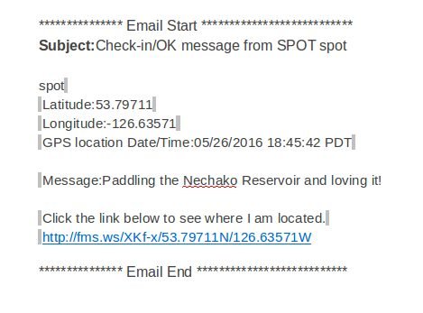
This is an amazing piece of equipment to have for people who do a lot of remote recreational activities. Every day, when we reached our final destination for the day, Maria would send out a spot message to a group of preselected recipients (e.g. her son, my wife...). The spot message gets sent out as an email to the preselected group to tell them that we are ok and gives them the exact GPS location that the message was sent from. In addition to this, the email gets a link that gives you a map view (on Google maps) of the exact location.
From what I understand, it has a three level message alert.
- level 1 - just notifies the preselected group of our location and that we're ok
- level 2 - notifies the preselected group that we need help
- level 3 is like a 911 call for emergency help
The emails that our recipients would get would look something like this:
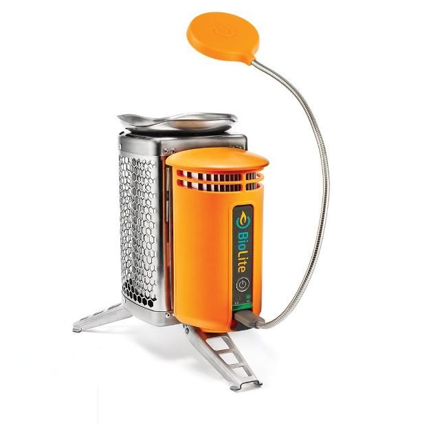
BioLite Wood Burning Campstove
This is one interesting piece of equipment that Maria and Arnie have. This stove gives you the ability to cook or boil water with just about anything that you can find and burn (e.g. wood chips, pine cones etc..). We were able to conserve a lot of the fuel for my WhisperLite stove by using the BioLite. Kick ass piece of equipment really. This stove would probably also be acceptable for use even during fire bans as it does not allow sparks to fly out. The forestry officers believed that it would be fine. They didn't seem to be too concerned about it as long as we used common sense. We did have a discussion about it with them.
BioLite (with USB charger):
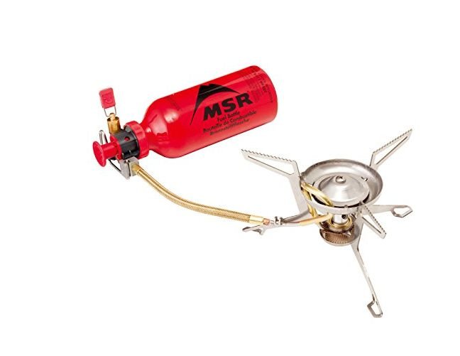
WhisperLite International (with fuel bottle):
Our Boats
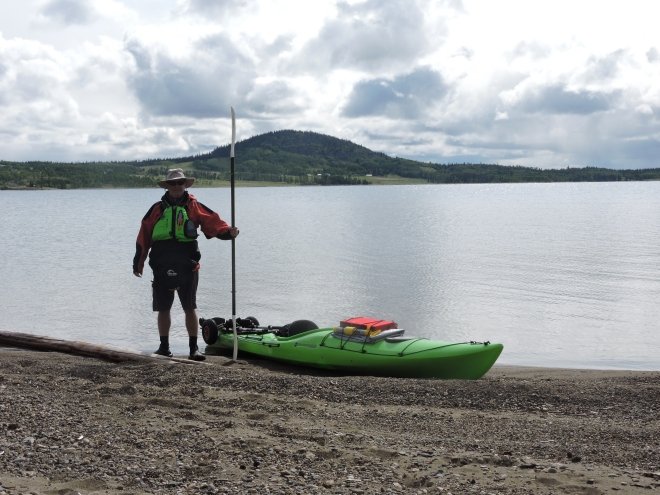
I had my Wilderness Systems - Tsunami 145. Click here for manufactuer's specs.
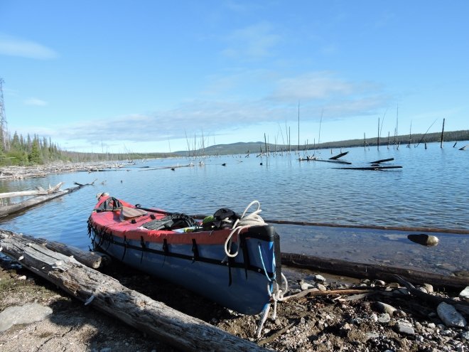
Maria and Arnie had their Hellman - Prospector. Click here for manufactuer's specs.
... and now for our journey. Here we go!
Next -->